
Maungdaw region is an internationally known area that includes only Maungdaw Township and Buthidaung Township within Maungdaw District. However, in the broader Maungdaw region, Rathedaung Township from Sittwe District is also included.
The Maungdaw region can be described as the area between the Naf River and the Aurama mountain range. However, it primarily refers to the areas stretching from Angumaw Port down to Taung Pyo Let Wai, Kha Maung Seik, and along the Bangladesh border, including the northern part of Buthidaung Township. It also extends to the tri-border area between Arakan, Bangladesh, and India, as well as the Paletwa border.
Maungdaw District is bordered to the south by Sittwe District, to the west by Bangladesh’s Cox’s Bazar District, and to the north by Bangladesh’s Bandarban District.
The Naf River, which flows between Maungdaw District and Cox’s Bazar District before merging into the Bay of Bengal, serves as the border between Arakan and Bangladesh. Its role as a hub for border trade makes it extremely significant.
Maungdaw District, consisting of Maungdaw Township and Buthidaung Township, is separated by the Mayu Mountain Range. However, Rathedaung Township and Angumaw coastal areas are directly connected to the lowland plains of Maungdaw Township.
In Maungdaw Township, Taung Pyo Let Wai, Kha Maung Seik, and Myin Hlut towns are included. Taung Pyo Let Wai is located along the border with Bangladesh and is significant as it hosts the Friendship Bridge, which facilitates overland travel and cross-border relations between the two countries.
The Maungdaw region lies between the Naf River and the Mayu River, as well as the western areas of the Arakan Yoma mountain range, extending to the Bay of Bengal. Its strategic location at the border and its access to international waters make it crucial for cross-border trade and maritime routes, as noted by border traders and policymakers.
Maungdaw Township stretches approximately 24 miles south to Thawun Chaung and over 60 miles north to Taung Pyo Let Wai. From its central point at Alay Thann Kyaw, the area extends westward to Rathedaung Township and Angumaw Port along the Bay of Bengal coastline. This strategic location allows for maritime navigation to Bangladesh and international waters, making it significant for trade and geopolitics, as noted by border traders and policymakers.
The Maungdaw region is located at the tri-border area of Arakan, Bangladesh, and India, stretching from the northern Sai Din mountain range to the southern Aurama Yoma and northern Wailartaung mountain ranges of the Mayu Range, including the northern foothills of the Mayu Range. These mountain ranges serve as natural strongholds. Additionally, the Mayu River and Naf River play crucial roles in maritime navigation, further enhancing the region’s strategic importance.
Military junta army bases
Maungdaw Township is bordered to the west and north by Bangladesh, with the Naf River stretching 41 miles and the mountain range extending 42 miles along the border. To the south, it is bordered by the Bay of Bengal and a coastline of 25 miles, while it is approximately 12 miles from Rathedaung Township. To the east, it borders Buthidaung Township, extending about 63 miles, as stated by the General Administration Department.
The Maungdaw region borders Bangladesh along a 168.57-mile stretch. From the Bay of Bengal and the Naf River in the south, it extends 39.82 miles north to the Naf River’s mouth. From the river mouth, the border continues along streams, mountain peaks, and the foothills, reaching the Arakan-Bangladesh border at BP 31, and then further along to the tri-border area of Arakan, Bangladesh, and India, extending up to BP 73, covering a total of 128.75 miles.
Therefore, in Maungdaw Township, in addition to the Maungdaw District Police Force, there are several units under the No. 1 Border Guard Headquarters, including the Office of the Commander, No. 1 Border Guard Police Command, the Office of the Deputy Commander, No. 1 Border Guard Police Command, the Office of the Deputy Commander, No. 2 Border Guard Police Command, No. 1 Border Guard Police Sub-division, No. 2 Border Guard Police Sub-division, No. 4 Border Guard Police Sub-division, No. 5 Border Guard Police Sub-division, No. 6 Border Guard Police Sub-division, No. 7 Border Guard Police Sub-division, No. 9 Border Guard Police Sub-division, and No. 10 Border Guard Police Sub-division.
In Buthidaung Township, there are the No. 15 Operations Command Headquarters, a tactical base, the No. 233 Infantry Battalion, the No. 234 Infantry Battalion, the No. 236 Infantry Battalion, the No. 245 Light Infantry Battalion, the No. 351 Light Infantry Battalion, the No. 353 Light Infantry Battalion, the No. 535 Light Infantry Battalion, the No. 551 Light Infantry Battalion, the No. 552 Light Infantry Battalion, the No. 564 Light Infantry Battalion, the No. 565 Light Infantry Battalion, and the No. 378 Artillery Battalion.
In addition, in Buthidaung town, there is the Buthidaung Township Police Station, the Office of the Deputy Commander of No. 3 Border Guard Police Command, the No. 3 Border Guard Police Sub-division, the No. 8 Border Guard Police Sub-division, and forces deployed from Division 22 and Division 55 to reinforce the area.
In Rathedaung Township, at Kha Naung Gyi plain, there were the No. 536 Light Infantry Battalion and the No. 537 Light Infantry Battalion, while at Ngatauk Tu Chay plain, there was the No. 538 Light Infantry Battalion, along with the Rasoe Chaung tactical base. Additionally, some areas on the eastern bank of the Mayu River and around Ngasan Baw Chaung were occupied by troops under Division 22. The Rathedaung Township Police Station was also located there.
In the Maungdaw region, the No. 1 Border Guard Police Command oversaw 11 township offices, 12 police stations, 129 checkpoints, 27 stream crossing posts, 12 boundary posts, and a total of 191 locations. In addition, there were 10 Border Guard Police sub-divisions under the command, along with security forces from No. 8, No. 12, and No. 25 security police sub-divisions, as well as troops from Division 77, Division 22, and Division 55, which were also deployed to reinforce the area.
The Maungdaw region, including Rathedaung, Buthidaung, and Maungdaw townships, is home to the largest deployment of military force in all of Arakan, with military camps, battalions, strategic positions, and armed forces under the control of the military junta. In addition to the Mayu River, Naf River, and areas surrounding the Bay of Bengal, the junta’s naval vessels and large warships were also stationed for military operations. Furthermore, five military helicopters were prepared and ready for action.
In the western region, where the Western Military Command is based in Ann Township and the regional junta office is located, military camps, Chaungwa posts, checkpoints, strategic bases, battalions, divisions, and the largest deployment of military forces are stationed in the Maungdaw region. This is confirmed by the list of junta troop strengths obtained by Border News Agency, which shows Maungdaw to have the highest concentration of military forces compared to other areas
Arakan War
The Arakan Army, formed on April 10, 2009, by 26 Arakanese youths in Laiza, Kachin State, where the KIO/KIA headquarters is located, managed to establish a presence in the Arakan region three years after its formation.
In 2014, a small-scale clash occurred between the Myanmar military and the Arakan Army in the northern part of Buthidaung Township, near the Arakan-Bengal border and the Wanet Yone area. This marked the beginning of the Arakan War.
Later, at the end of 2015, intense clashes occurred between the Arakan Army (AA) and the Myanmar military near Yoe Chaung Phyar in Kyauk Taw Township and near the O Rama mountain range in Rathedaung Township. This led to the first instance of Arakan civilians fleeing due to the conflict.
Although no direct clashes occurred for nearly three years after that, by the end of 2018, battles reportedly resumed near the Sai Din mountain range in Buthidaung Township, as well as in areas such as Rathedaung, Kyauk Taw, and Ponna Kyun, marking the beginning of new confrontations.
On January 4, 2019, Myanmar’s Independence Day, under the administration of the National League for Democracy (NLD), the Arakan Army launched a coordinated attack on four Myanmar military outposts in the northern part of Buthidaung Township, successfully raiding them.
On March 6, 2019, at the intersection of the O Rama mountain range near the Buddhao village, where the boundaries of Buthidaung, Ponna Kyun, and Kyauk Taw townships meet, intense clashes broke out between the Arakan Army (AA) and the Myanmar military. This battle was the longest, fiercest, and deadliest conflict in the Arakan region, with the highest casualties on both sides. It was also the first time the Myanmar military used aircraft in the conflict, according to the Arakan Army.
After more than five decades since the 1970 Battle of Kwanlon between the Communist Party of Burma (CPB) and the Myanmar military, intense battles broke out once again between the Arakan Army (AA) and the Myanmar military. The clashes started on February 5, 2020, and lasted for 43 days, with the Arakan Army describing them as the most intense confrontations in a “MiWa Byuha” conflict.
Before the conclusion of the MiWa battle, on the night of March 22, 2020, the Arakan Army (AA) launched an attack on the Myanmar military’s advanced training school located near Kan Ni village in Minbya Township.
From the time the Arakan Army (AA) established its presence in the Arakan region until the ceasefire in 2020, although direct confrontations did not occur within Maungdaw Township, the Maungdaw northern region initiated the Rakhine Offensive, which marked the beginning of the final decisive battle in the Arakan region.
Western Border
The Arakan Army, when it began operating with weapons and troops from the eastern to the western borders of Myanmar, established a presence in the Arakan region, utilizing the border areas of the three countries—Myanmar, Bangladesh, and India—as the primary routes for its movements and operations.
After the start of the Arakan conflict, the Arakan Army gained significant support and trust from the people of Arakan. This resulted in an expansion of the conflict zones, and the establishment of military training schools within the Arakan region, which helped increase the strength of the Arakan Army, with its membership growing to over tens of thousands.
In the Arakan conflict, the Myanmar junta’s forces have blocked transportation routes, cut off communication lines such as phone and internet services, and imposed restrictions on food and medical supplies. However, these measures have not caused military pressure or losses for the Arakan Army (AA), which operates with strongholds near the tri-border region.
The international community has stated that the Myanmar junta, which is facing charges of genocide against the Rohingya muslims in Maungdaw, is exacerbating war crimes in Arakan by blocking transportation routes, cutting off phone and internet communications, and restricting access to food and medical supplies.
The international community has noted that the Myanmar junta, which is facing genocide charges internationally, is under pressure regarding the Rohingya repatriation issue, particularly from neighboring Bangladesh. This situation has made the western border strategically advantageous for the Arakan Army (AA) and the people of Arakan.
Political analysts have noted that India’s Act East Policy and the Kaladan Multi-Modal Transit Transport Project are not only significant for India’s landlocked regions but also hold strategic importance for Myanmar’s western border, particularly in areas controlled by the Arakan Army (AA).
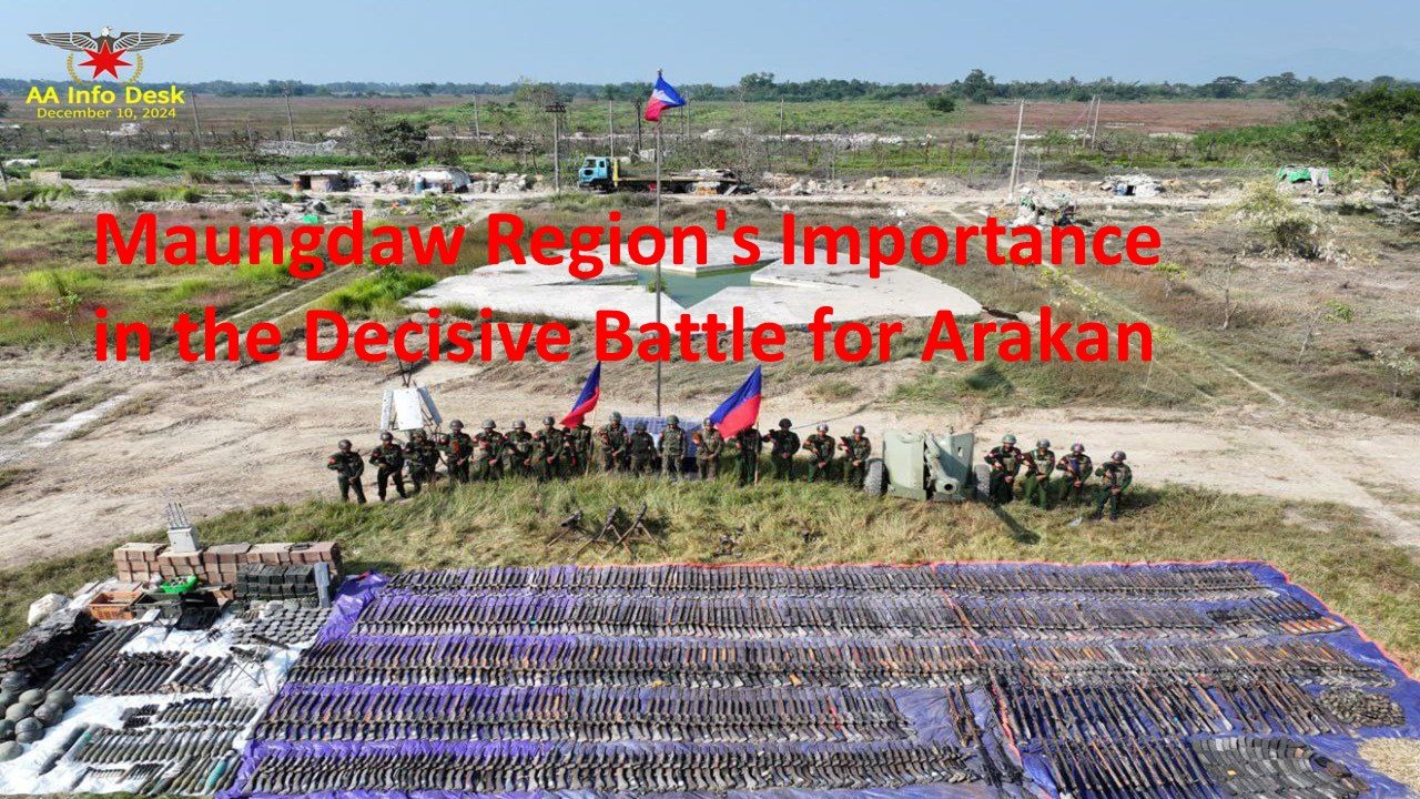
In addition to that project, the Arakan Army (AA) has now fully taken control of the entire western border, including the Maungdaw border trade, which has been a key source of foreign income and U.S. dollars for the Myanmar junta.
The Three Brotherhood Alliance, which is militarily positioned to apply the greatest pressure to uproot the military dictatorship, has seen significant success in Operation 1027. The Arakan Army (AA), as part of this alliance, has taken control of most towns, including the strategic Paletwa area.
The Arakan Army (AA) is now conducting offensives to fully capture and control all remaining exit points, including the tri-border area between Arakan, Bangladesh, and India.
The Decisive Battle for Arakan
During the periods of conflict between the Arakan Army (AA) and the Myanmar junta in Arakan, the junta imposed blockades only on towns and areas where fighting was most intense. However, in the decisive battle, they imposed a simultaneous and complete blockade across the entire Arakan region.
Additionally, the Myanmar junta is implementing a harsh strategy targeting civilians, imposing strict restrictions on town entry and exit points, waterway travel, fishing activities, and rice harvesting. Simultaneously, they are carrying out heavy and small arms fire, arson, and destruction.
What is even more severe is that the Myanmar junta is threatening and pressuring rice mill associations, fuel business owners, rice depots, and fuel shops to stop selling rice and fuel. They are also arresting vendors and fishermen, which analysts say is putting immense pressure on the entire Arakan population, pushing them toward armed resistance.
Furthermore, the Myanmar junta’s forces are carrying out deliberate arson attacks on towns, markets, neighborhoods, and villages, as well as forcibly seizing civilian property, including medicine and food supplies purchased by civilians. Arakan residents claim these actions are occurring daily and continuously.
As a result, the entire Arakan population is facing starvation, food shortages, a lack of sufficient medicine, and inadequate shelter. Additionally, they are enduring the constant impacts of heavy artillery shelling on a daily basis, according to reports from residents.
To overcome these crises, political analysts emphasize the urgent need to establish a secure and reliable liberated border territory. This would allow the import and distribution of all essential supplies for the entire Arakan region from neighboring countries.
“Control over the Arakan-India-Bangladesh border and the capture of Maungdaw Township have enabled free trade. For the issue of repatriation, the international community will now have to engage directly with the Arakan Army. The complete capture and administration of the Maungdaw region marks the decisive moment for Arakan,” said a Member of Parliament from Maungdaw District in his analysis.
Analysts monitoring Rakhine affairs have stated that with the Arakan Army (AA) having fully captured the tri-border region, including Paletwa and the Arakan-Bangladesh border, the international community may begin recognizing and engaging with the Arakan People’s Revolutionary Government. Additionally, border trade between the two neighboring countries can resume, making Maungdaw a critical area in the decisive battle for Arakan.


